Florida Marine Weather

Know Before You Go - Get A Forecast
Make a habit of getting a local forecast
before you leave the dock! You can listen to the radio, watch the TV,
visit the NOAA Website (links below) or use your VHF radio (see info
below) to get local updates.
Underway - Scan the Airwaves and the Horizon
On the water, the best way to receive timely
weather information is by radio. NOAA Weather Radio provides continuous
weather programming for Florida.
|
Weather Radio Broadcast Frequencies |
NOAA Weather Radio
(Range approx. 40 miles) |
WX-1, WX-2, WX-3 |
| VHF Channel 22A |
157.1 MHz |
| Coast Guard Marine
Information Stations |
2670.0 kH, 4428.7 kH,
6506.4 kH, 8765.4 kH, 13113.2 kH |
| National Bureau of
Standards Time & Frequency Service |
5, 10, 15 MHz |
Although sportsmen may have better luck
on cloudy or windy days, being out in a boat in bad weather can be very
risky. High winds, rough water and thunderstorms can suddenly turn a
pleasant outing into a frightening experience. When you go out on your
boat, you should know the current forecast, and have a way to receive
warnings and weather advisories while underway. Making boating safety
your first priority is the best way to assure you'll be back again for
another great fishing or cruising trip!
Even with today's high-tech weather
forecasts and a radio aboard to receive them, there's no substitute for
the time-honored practice of scanning the horizon for changes in the
wind, waves, water, and sky that signal developing weather patterns.
Other
Mariner Services
National Weather Service
Coastal Water Temperature Guide
Seawinds National Wind Map
Notice to Mariners
Disasters & Emergencies
National Hurricane Center
Weather Basics
Florida's rapidly changing weather
conditions have ruined an enjoyable day for many boaters on our waters.
It's always a smart plan to check the local weather and water
conditions before leaving for the boat ramp. Take a few extra minutes to
check the conditions before you leave. It may save you from a miserable
day.
A good weather forecast is no guarantee
that the weather will be in your favor all day. Occasional storms may
appear without warning. Always keep an eye out for changes in the
weather, and do not hesitate to head for safe waters. Remember, lighting
strikes are a fairly common occurrence in Florida, and may happen
several miles away from the nearest storm.
Weather Underground Marine Map
Lightning
Lightning is an electrical discharge
between one part of a cloud and another, between two clouds, or between
a cloud and the earth. The best protection against lightning is
avoidance. Keep a weather eye out for the coppery haze and building
cumulonimbus clouds that signal thunderstorms, and head into shore well
ahead of the turbulence. Lightning can lash out for miles in front of a
storm, and it can strike after a storm seems to have passed. For
information on lightning protection, go to NOAA.
Florida Weather Records
Deadliest Hurricane:
September 17, 1928. More than 2,500 people killed and
drowned along Lake Okeechobee when extreme winds sent the lake's waters
over surrounding levees.
Costliest Hurricane: August 24, 1992. Hurricane Andrew caused $25
billion in damage, mostly in Miami-Dade County.
Most Powerful Hurricane: Labor Day, 1935. Winds estimated at 185
mph on Long Key.
Highest Temperature: June 29, 1931. 109° F at Monticello.
Lowest Temperature: February 13, 1899. -2° F at Tallahassee.
Most Rain in 24 Hours: September 5-6, 1950. 38.7 inches at
Yankeetown.
Greatest Snowstorm: January 10, 1800. 5 inches near mouth of St.
Mary's River, along Florida-Georgia border.
National Weather Service Recorded Forecasts
South Florida - 305-229-4550
Jacksonville - 904-741-4311
Tampa - 813-645-2506
Key West - 305-295-1316
Florida's
Gulf Stream
The purple majesty known as the Gulf
Stream courses through the Florida Straits south of Key West and moves
steadily northward along the entire east coast of Florida. Like its
color, its pace is majestic, a steady 4 knots. It's a mighty tropical
river from 24 to 40 miles in width. Its temperature varies from a
summertime 86° F off Key West to 75° F off Jacksonville in winter.
|
Local
Weather Forecasts
Florida Radar
Weather Tips for Smooth Sailing
Weather prediction is not a
perfect science. The prudent sportsman won't go out without a weather
forecast. But conditions can change quickly, so you must also observe
current conditions and be aware of changing weather patterns around you.
Before Setting Out
Obtain the latest weather
forecast for your boating area. When weather warnings are in effect,
don't venture out unless you are confident your boat can be navigated
safely. Equip your boat properly so you won't be stranded in an
emergency:
- A sturdy anchor and line of the appropriate size and length
- Paddle or oars in case of engine failure or torn sails
- Visual distress signals to call for help
While Underway
Check radio weather broadcasts
frequently. Heavy static on your radio (AM not FM) may indicate nearby
storm activity. Keep a weather eye out for:
- Dark, threatening clouds that may indicate a squall or thunderstorm
approaching
- Any steady increase in wind or sea
- Any increase in wind velocity opposite in direction to a strong
tidal current. A dangerous rip condition may form steep, perilous waves.
Winds and Waves
4-6 mph wind makes 1 ft or less seas
7-10 mph wind makes 1-2 ft seas
11-15 mph wind makes 2-4 ft seas
16-20 mph wind makes 4-6 ft seas
Check current wind conditions
Weather Aids
National Data Buoy Center
NOAA National Ocean Service
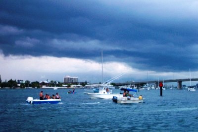
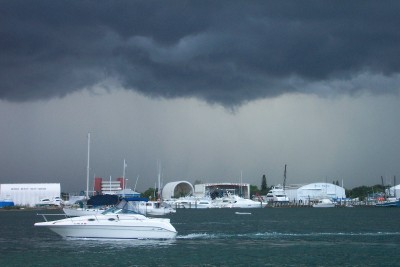
Thunderstorms
Thunderstorms are created when warm,
moist air rises, cools and condenses. It swells into mounds of
thick, billowy cumulus clouds that quickly darken into the
towering, ominous-looking cumulonimbus clouds characteristic of
thunderstorms.
Consider the formation of this thick,
dark cloud an unmistakable thunderstorm warming, and head
immediately for safe anchorage. The transition from a small cloud
into a turbulent, electrified storm front can occur in as little as
30 minutes. Strong, gusty winds and heavy rains with thunder and
lightning will soon follow. Fortunately, few squalls last more than
an hour.
The sharper, darker and lower the front
edge of the cloud, the more severe the storm. The anvil-shaped top of
the storm cloud points in the direction the storm is traveling.
In summer, afternoon thunderstorms are
likely to occur over water when the humidity and temperature ashore
are high. Hot air radiates upward from land surfaces heated by the
sun. Moisture from a nearby body of water is absorbed by the warm
air, which rises to begin the formation of thunderheads. They
usually appear as swift-moving black clouds, often approaching from
the southwest, south or west at speeds of 25-35 knots.
You can determine the distance of an
approaching thunderstorm by counting the number of seconds between
the lightning flash and the thunder clap, and dividing by five. that
will give you the distance in miles you are from the storm. For
example, if the time lapse between the lightning flash and the
thunder clap is 10 seconds, divide by 5. The storm is approximately
2 miles away from you.
Typical
Clouds
Cumulonimbus
Altostratus
Cumulus
Stratocumulus
Fog
Towering Cumulus
Cirrus
Hurricane Squall
Some text on this page provided by the
U.S. Foundation for Boating Safety.
|